


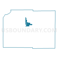
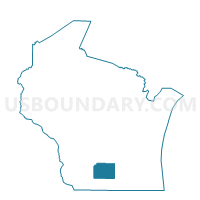
WESTPORT - T 4 Voting District, Dane County, Wisconsin
About
Outline

Summary
| Unique Area Identifier | 692946 |
| Name | WESTPORT - T 4 Voting District |
| County | Dane County |
| State | Wisconsin |
| Area (square miles) | 11.58 |
| Land Area (square miles) | 6.82 |
| Water Area (square miles) | 4.76 |
| % of Land Area | 58.90 |
| % of Water Area | 41.10 |
| Latitude of the Internal Point | 43.12952290 |
| Longtitude of the Internal Point | -89.45184840 |
Maps

Graphs
Select a template below for downloading or customizing gragh for WESTPORT - T 4 Voting District, Dane County, Wisconsin


Neighbors
Neighoring Voting District (by Name) Neighboring Voting District on the Map
- DANE - T 1 Voting District, Dane County, WI
- Madison - C 22 Voting District, Dane County, WI
- Madison - C 74 Voting District, Dane County, WI
- Maple Bluff - V 2 Voting District, Dane County, WI
- Middleton - C 6 Voting District, Dane County, WI
- Middleton - C 7 Voting District, Dane County, WI
- Middleton - C 8 Voting District, Dane County, WI
- SPRINGFIELD - T 1 Voting District, Dane County, WI
- SPRINGFIELD - T 3 Voting District, Dane County, WI
- VIENNA - T 1 Voting District, Dane County, WI
- Waunakee - V 1 Voting District, Dane County, WI
- Waunakee - V 6 Voting District, Dane County, WI
- Waunakee - V 7 Voting District, Dane County, WI
- Waunakee - V 9 Voting District, Dane County, WI
- WESTPORT - T 2 Voting District, Dane County, WI
- WESTPORT - T 3 Voting District, Dane County, WI
Top 10 Neighboring County Subdivision (by Population) Neighboring County Subdivision on the Map
- Madison city, Dane County, WI (233,209)
- Middleton city, Dane County, WI (17,442)
- Waunakee village, Dane County, WI (12,097)
- Westport town, Dane County, WI (3,950)
- Springfield town, Dane County, WI (2,734)
- Vienna town, Dane County, WI (1,482)
- Maple Bluff village, Dane County, WI (1,313)
- Dane town, Dane County, WI (990)
Top 10 Neighboring Place (by Population) Neighboring Place on the Map
- Madison city, WI (233,209)
- Middleton city, WI (17,442)
- Waunakee village, WI (12,097)
- Maple Bluff village, WI (1,313)
Top 10 Neighboring Unified School District (by Population) Neighboring Unified School District on the Map
- Madison Metropolitan School District, WI (226,308)
- Middleton-Cross Plains School District, WI (37,298)
- Waunakee Community School District, WI (18,147)
- School District Not Defined (Water), WI (0)
Top 10 Neighboring State Legislative District Lower Chamber (by Population) Neighboring State Legislative District Lower Chamber on the Map
- Assembly District 79, WI (76,116)
- Assembly District 47, WI (61,697)
- Assembly District 81, WI (61,347)
- Assembly District 78, WI (55,031)
- Assembly District 77, WI (51,957)
Top 10 Neighboring State Legislative District Upper Chamber (by Population) Neighboring State Legislative District Upper Chamber on the Map
- State Senate District 27, WI (197,821)
- State Senate District 16, WI (188,936)
- State Senate District 26, WI (168,577)
Top 10 Neighboring 111th Congressional District (by Population) Neighboring 111th Congressional District on the Map
Top 10 Neighboring Census Tract (by Population) Neighboring Census Tract on the Map
- Census Tract 132, Dane County, WI (8,573)
- Census Tract 112, Dane County, WI (8,440)
- Census Tract 111.02, Dane County, WI (8,031)
- Census Tract 113.01, Dane County, WI (6,317)
- Census Tract 111.01, Dane County, WI (4,573)
- Census Tract 113.02, Dane County, WI (3,015)
- Census Tract 23.01, Dane County, WI (2,994)
- Census Tract 23.02, Dane County, WI (1,810)
- Census Tract 102, Dane County, WI (1,268)
- Census Tract 9917.02, Dane County, WI (0)